- Success Stories
- Environmental Resource Assessment & Management
Developing a Stream Assessment Protocol

CSS has been a significant contributor to the development and implementation of the Oregon Stream Function Assessment Method (SFAM) for more than 10 years. SFAM is a key component of the Oregon Stream Mitigation Program administered by the Oregon Department of State Lands.
The mitigation program is designed to address damage to aquatic resources caused by permitted activities, such as road construction, and commercial building. CSS employee owners have provided support for method development including field trials, data analysis, and expertise in developing the Excel-based stream assessment scoring tool. In addition, CSS employee owners helped write the SFAM Manual and Scientific Rational support document. Visit Oregon Department of State Lands website to learn more about this program.

See More CSS Insights

Overcoming COVID-19 Challenges
Great job to our team supporting our contract with the U.S. General Services Administration on assisting the client with conducting a year’s worth of environmental, health, and safety surveys in just six months! Due to limitations with COVID-19, the team was unable to conduct their surveys on their usual timeline and instead had to work…
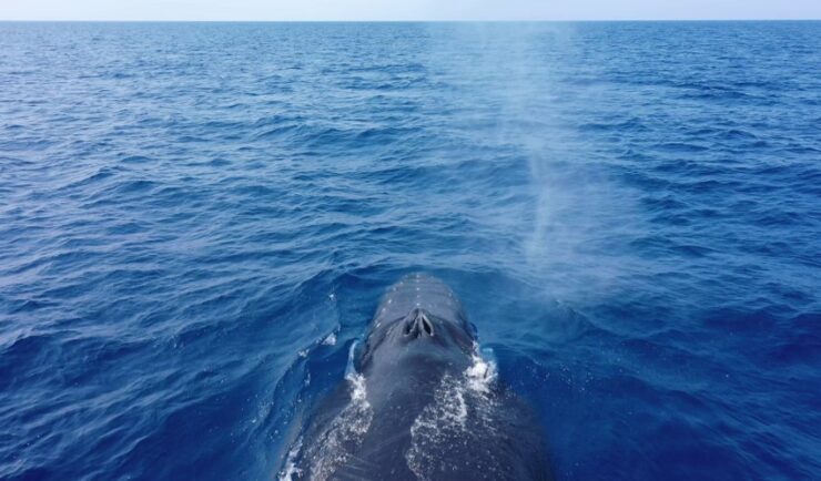
Training Marine Mammal Programs to Use Drones to Collect Dolphin and Whale Respiratory Health Data
CSS employee owner and Marine Mammal Drone Specialist supports NOAA’s National Centers for Coastal Ocean Science (NCCOS) Marine Mammal Health Assessment team with collecting respiratory health data from marine mammals in local waterways. Using specialized drones equipped with petri dishes provides a non-invasive method to collect exhaled breath (i.e. blow) samples from dolphins and whales.…
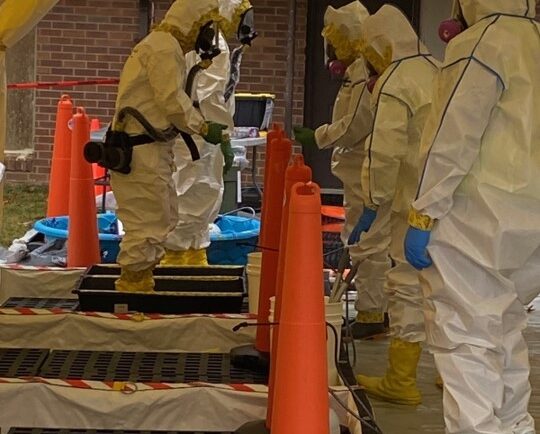
Developing a Decontamination Line Guide for EPA Responders
CSS employee owners supporting the Environmental Protection Agency’s (EPA) Scientific and Technical Assistance for Consequence Management (STACM) contract have been working with the National Chemical Preparedness Workgroup and Sub Workgroups to create a decontamination (decon) line guide and detailed drawing for EPA on-scene coordinators and EPA’s special teams to use for emergency responses and incidents. The…